


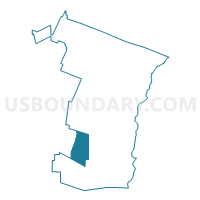
Ludlow Voting District, Windsor County, Vermont
About
Outline

Summary
| Unique Area Identifier | 680960 |
| Name | Ludlow Voting District |
| County | Windsor County |
| State | Vermont |
| Area (square miles) | 35.70 |
| Land Area (square miles) | 35.18 |
| Water Area (square miles) | 0.52 |
| % of Land Area | 98.54 |
| % of Water Area | 1.46 |
| Latitude of the Internal Point | 43.39528630 |
| Longtitude of the Internal Point | -72.70380350 |
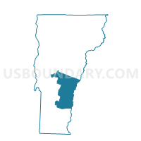
Maps

Graphs
Select a template below for downloading or customizing gragh for Ludlow Voting District, Windsor County, Vermont


Neighbors
Neighoring Voting District (by Name) Neighboring Voting District on the Map
- Andover Voting District, Windsor County, VT
- Cavendish Voting District, Windsor County, VT
- Chester Voting District, Windsor County, VT
- Mount Holly Voting District, Rutland County, VT
- Plymouth Voting District, Windsor County, VT
- Weston Voting District, Windsor County, VT
Top 10 Neighboring County Subdivision (by Population) Neighboring County Subdivision on the Map
- Chester town, Windsor County, VT (3,154)
- Ludlow town, Windsor County, VT (1,963)
- Cavendish town, Windsor County, VT (1,367)
- Mount Holly town, Rutland County, VT (1,237)
- Plymouth town, Windsor County, VT (619)
- Weston town, Windsor County, VT (566)
- Andover town, Windsor County, VT (467)
Top 10 Neighboring Place (by Population) Neighboring Place on the Map
Top 10 Neighboring Elementary School District (by Population) Neighboring Elementary School District on the Map
- Chester-Andover Union School District 29, VT (3,621)
- Ludlow School District, VT (1,963)
- Cavendish School District, VT (1,367)
- Mount Holly School District, VT (1,237)
- Plymouth School District, VT (619)
Top 10 Neighboring Secondary School District (by Population) Neighboring Secondary School District on the Map
- Green Mountain Union High School District 35, VT (4,988)
- Black River Union School District 39, VT (3,200)
Top 10 Neighboring Unified School District (by Population) Neighboring Unified School District on the Map
Top 10 Neighboring State Legislative District Lower Chamber (by Population) Neighboring State Legislative District Lower Chamber on the Map
- Windham-Bennington-Windsor State House District, VT (4,355)
- Windsor-2 State House District, VT (4,192)
- Windsor-1-1 State House District, VT (3,991)
- Windsor-Rutland-1 State House District, VT (3,819)
Top 10 Neighboring State Legislative District Upper Chamber (by Population) Neighboring State Legislative District Upper Chamber on the Map
Top 10 Neighboring 111th Congressional District (by Population) Neighboring 111th Congressional District on the Map
Top 10 Neighboring Census Tract (by Population) Neighboring Census Tract on the Map
- Census Tract 9665, Windsor County, VT (4,187)
- Census Tract 9659, Windsor County, VT (3,320)
- Census Tract 9640, Rutland County, VT (3,316)
- Census Tract 9663, Windsor County, VT (1,963)
- Census Tract 9662, Windsor County, VT (1,611)